Tenerife is a real playground for hiking enthusiasts! We explored exceptional trails, from the lunar landscapes of Teide National Park to the lush green forests of the Anaga Massif. This Canary Island offers remarkable diversity, from Spain’s highest peak to wild gorges and unspoilt coastlines. Whether you’re an experienced hiker or an occasional walker, we’ve found routes in Tenerife to suit all levels.
Here is our selection of the 10 best hikes in Tenerife with our useful tips in pictures!
This opinion is completely independent, based on our experiences. We visited the region anonymously, making our own choices and paying our bills in full.
Content
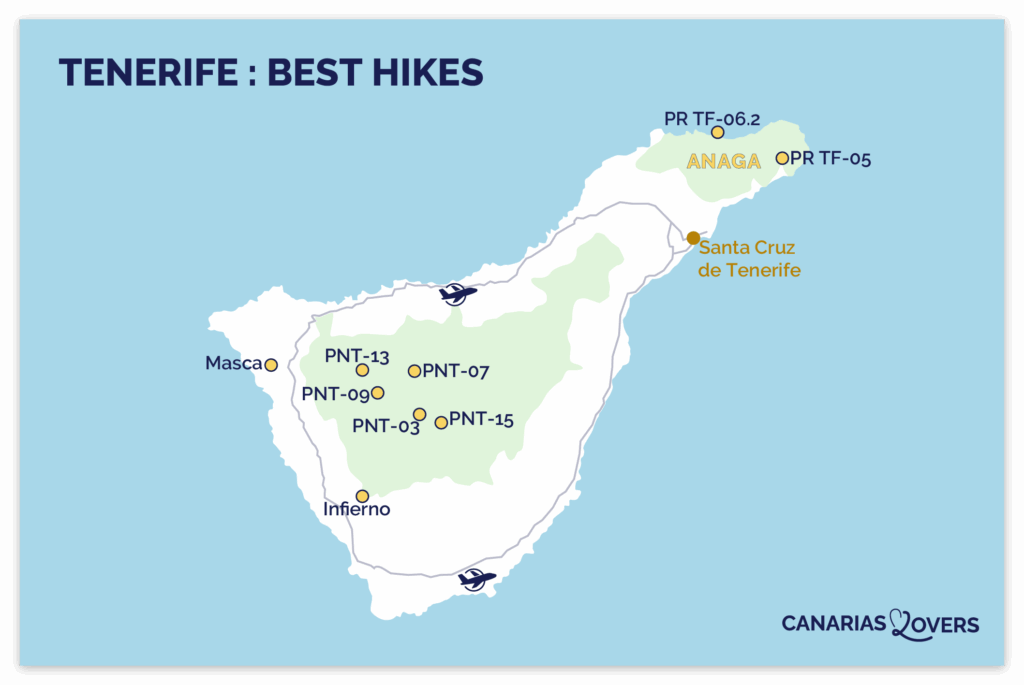
The best walks in Tenerife: map
In Tenerife, we loved the diversity of landscapes the island has to offer. Many hikes are concentrated in the Teide National Park, a UNESCO World Heritage site. The site is home to Spain’s highest peak and offers an absolutely unique lunar landscape. Other itineraries, less arid and more verdant, can be found in the Anaga Massif, where lush vegetation contrasts with volcanic areas. Before setting off, we would like to remind you to respect the signs, stay on the marked trails and do not disturb or remove any natural elements.
Here’s a map of the best hikes to help you find your way around the island:
If you only need to do 3, we recommend it:
- The Montaña Blanca hike to the summit of Teide
- The Barranco de Masca to explore spectacular gorges
- Anaga Park trails to discover the laurel forest
1. PNT-07 Montaña Blanca – La Rambleta (top of Teide cable car)

Why go there? Our review
The PNT-07 Montaña Blanca – La Rambleta hike offers, in our opinion, the most impressive view in the whole of Tenerife! This demanding ascent leads to the summit of Teide, Spain’s highest peak, perched at 3718m. The trail passes through extraordinary volcanic landscapes. Contemplate petrified lava flows and astonishing geological formations. It’s well worth the effort: at the top, you’ll discover a 360° panorama of the whole island and, on a clear day, of the Canary Archipelago. The breathtaking panorama of Teide National Park from La Rambleta left a deep impression on us.

Useful tips
- Location: Teide National Park, in the center of the island.
- Access: departure is from the Montaña Blanca parking lot, accessible via the TF-21 road. You can get there by bus no. 348 and 342, “Montaña Blanca” stop – details here.
- Permits required: reservation and Teide access permit required to climb on foot. Book them in advance on the official national park website here.
- Mandatory equipment: hiking boots, water, warm jacket, thermal blanket, charged telephone, long pants, gloves and hat, headlamp.
- Type of route: linear
- Walking time: between 6h and 9h depending on your physical condition (8.29km)
- Difficulty: difficult. The altitude and vertical drop of 1309.08m make this a demanding hike.
- Best time: we recommend setting off early in the morning to avoid the heat and enjoy the sunrise at the summit.
- Opening hours: check that the trail is open to the public upstream .
- Accessibility: not accessible to people with reduced mobility.
WHERE TO STAY IN Tenerife
Our independent picks for the accommodation of your dreams:
- Where to stay in Tenerife
- Our favorite: Hotel Corales Beach
Select by hotel type:
- 5-star hotels
- Best boutique-hotels
- Best hotels for families
- Best hotels in Seaside
- Best adults-only hotels
- Best all-inclusive hotels (coming soon)
Select by city:

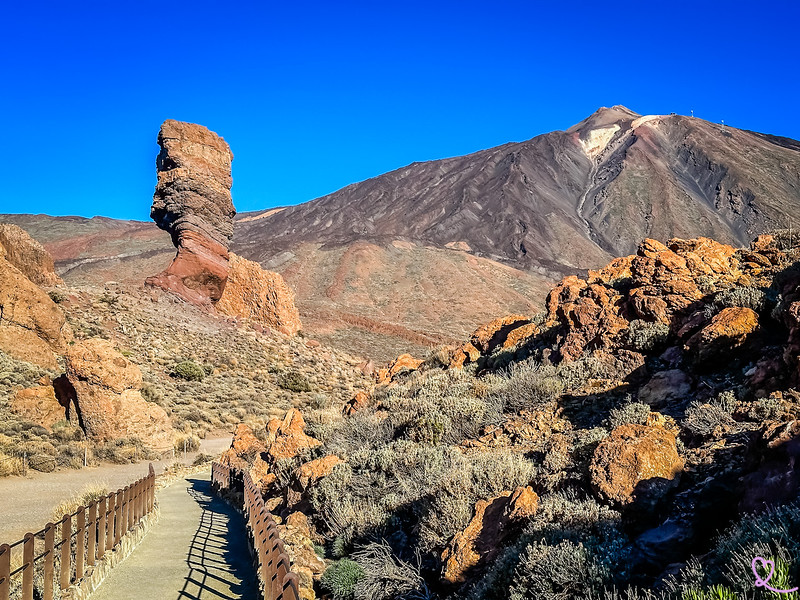
2. PNT-03 Roques de García (Teide)

Why go there? Our review
The Roques de García are the easiest hike in Teide National Park, perfect for families! We loved this very well laid-out circuit, which passes right by spectacular rocks with astonishing shapes. Information panels line the route, making the visit both instructive and enjoyable. This free walk takes in geological sights such as the famous Roque Cinchado, nicknamed “the finger of God”. We also enjoyed the typical flora and fauna of the area. In our opinion, this is one of the most beautiful landscapes on Tenerife!

Useful tips
- Location: Teide National Park, in the center of the island.
- Access: The site is accessed from the south or west of the island via TF-21. The road is well-maintained, wide and offers many panoramic views.
- Type of route: loop
- Duration: 1h to 1h30 walk (3.47km)
- Difficulty: easy. The ride is pretty straightforward and quick. But be careful: we’re at an altitude of over 2,000m and the sun is beating down hard.
- Best time: early morning or late afternoon to avoid crowds and heat.
- Infrastructure: ample free parking, visitor information center nearby.
- Opening: check that the trail is open to the public upstream here.
- Accessibility: the first section is accessible to people with reduced mobility, but the rest of the trail is not.
- Book your hike with an expert Teide National Park guide here!
3. Barranco de Masca trail (Teno Rural Park)

Why go there? Our review
The Barranco de Masca is without doubt Tenerife’s most beautiful gorge hike! This spectacular descent runs from the hilltop village of Masca to the sea, and more specifically to Playa de Masca. The trail winds between dizzying rock faces, through changing vegetation and offers breathtaking views at every turn. You’ll discover endemic species. Access to the gorges is strictly regulated to preserve the site and ensure the safety of hikers.

Useful tips
- Location: west of the island, in the Teno Massif.
- Access: the start is in the village of Masca. Access required by bus no. 355, as proof of public transport is required to access the trail – details here.
- Reservations essential: access to the trail is limited and subject to a fee. Prior booking is required. A boat ticket and proof of bus no. 355 are required at check-in. Book in advance on the official website here.
- Mandatory equipment: hiking boots, suitable clothing, water, energy snacks, charged telephone.
- Type of journey: one-way. The return journey is usually by boat from Playa de Masca to Los Gigantes.
- Duration: 3h to 4h descent (5km)
- Difficulty: difficult. The descent is steep in places and the terrain can be slippery.
- Best time: early morning to avoid the heat in the gorges.
- Infrastructure: Masca visitor center (pre-hike checkpoint). A few restaurants and cafés in the village.
- Accessibility: not accessible to people with reduced mobility.
- Book your guided tour here to enjoy the trail without stress or constraints!
OUR TIPS TO RENT A CAR IN Tenerife
- Compare prices on our preferred platform: DiscoverCars – one of the best rated sites.
- If you’re planning to explore the mountains, don ‘t take the smallest cars. A more powerful engine will be more comfortable.
- But don’t take too big a car either, as some roads are narrow.
- There’s a lot of demand and it’s an island, so book early.

4. Hiking in Anaga Rural Park

Why go there? Our review
Anaga Rural Park offers a striking contrast with the volcanic landscapes of Teide. Here, the prehistoric laurel, a UNESCO Biosphere Reserve, envelops the trails in an almost mystical atmosphere. We were fascinated by these rainforests, where moss-covered trunks, light mist and lush vegetation create a timeless atmosphere.
The region offers trails to suit everyone, from the family-friendly to the more athletic. We recommend the La Ensillada – Cabezo de Tejo loop (medium level, 2h30), as well as 2 easy options for children: Bosque de Los Enigmas (1h40) and Pista de Las Hiedras (1h30). An interactive map of all the hikes in the massif makes it easy to choose your itinerary here.

Useful tips
- Location: north-east of the island, Massif d’Anaga.
- Access: Route TF-12 crosses the massif and leads to the starting points for hikes. This is a relatively narrow but well-maintained mountain road.
- Permits: some trails require a permit, which must be obtained online in advance. Check before you visit here.
- Type of route: varies according to the trail chosen (loops or round trips)
- Duration: 1h30 to 5h depending on itinerary
- Difficulty: from easy to difficult, depending on the trail
- Best time: all year round. The region is often foggy, which adds to its mysterious charm.
- Infrastructure: a few bars and restaurants in the departure villages. Visitor information center in Cruz del Carmen.
5. Barranco del Infierno hike (Adeje)

Why go there? Our review
Nestled in the heart of a nature reserve, the Barranco del Infierno hike won us over with its magnificent undulating landscapes and well-marked trail. Accessible by reservation only, these impressive gorges offer a spectacular journey through sheer cliffs, lush vegetation and hidden waterfalls. The path winds its way through the mountains, offering breathtaking panoramic views all the way to the ocean. This lush environment contrasts with the more arid areas of Tenerife. In our opinion, it’sone of Costa Adeje’s best attractions.

Useful tips
- Location: southwest of the island, in Adeje.
- Access: the starting point is at the visitor center at the end of Calle de los Molinos.
- Reservations essential: departure every 30 minutes for small groups of 20 people maximum. Book online in advance on the official website here.
- Admission: €15 for adults and €7.50 for children (aged 5 to 12).
- Type of route: round trip
- Duration: 2h30 to 3h (6.5km)
- Difficulty: low to medium. A few steeper sections, but a well-maintained trail.
- Best time: all year round. In summer, the coolness of the gorge is particularly pleasant in the early morning.
- Infrastructure: Adeje – Casa Fuerte parking lot (8-minute walk). Welcome center with toilets and departure information. Restaurant Otelo.
- Accessibility: not accessible to people with reduced mobility.
A LITTLE MORE patience
All the photos, maps, information and addresses you need to make your stay in the Canaries a success will soon be available in a single ebook!
If you’d like to be notified when our guide to the Canaries is published, please subscribe:
6. PNT-09 Teide – Pico Viejo – Mirador de Las Narices del Teide

Why go there? Our review
This hike is for experienced walkers who want to discover the landscapes shaped by Teide’s last eruptions in the Middle Ages. The demanding but spectacular trail offers close-up views of the vast 800m-wide crater of Pico Viejo and the impressive volcanic chimneys of Las Narices del Teide. There are powerful panoramic views of Pico Viejo, Tenerife’s second highest peak at 3104m. We particularly liked the Mirador de Las Narices del Teide, which offers a breathtaking view of the ancient eruptive vents and reveals the full power of the island’s volcanic history.
Useful tips
- Location: Teide National Park, in the center of the island.
- Access: the start is near the information panel at the Pico Viejo lookout (accessible via the Teide cable car).
- Permits required: reservation and Teide access permit required to climb on foot. Book them in advance on the official national park website here.
- Mandatory equipment: hiking boots, water, warm jacket, thermal blanket, charged telephone, long pants, gloves and hat, headlamp.
- Type of route: linear
- Duration: approx. 5h10 (9.61km)
- Difficulty: high. Significant gradient and high altitude.
- Best time: May to October for optimum conditions. Leave very early in the morning.
- Infrastructure: restaurant and toilets at the cable car.
- Opening hours: check that the trail is open to the public upstream .
- Accessibility: not accessible to people with reduced mobility.
7. PR TF-05 Chamorga – Igueste de San Andrés

Why go there? Our review
The PR-TF 05 Chamorga – Igueste de San Andrés seduces with its wild beauty and authenticity. The trail passes through the verdant Anaga massif, its lush laurel forests, and reveals isolated hamlets such as La Cumbrilla or El Lomo de Las Bodegas, before leading to the charming coastal village of Igueste de San Andrés. We particularly liked the latter, a true haven of peace nestled in the heart of dense, lush vegetation. Between laurel forests, rural villages and spectacular ocean views, this hike offers an exceptional overview of the region’s natural wealth.
Useful tips
- Location: north-east of the island, Anaga Rural Park.
- Access: the starting point is Chamorga, a village accessible by car via Route TF-123. You can get there by bus no. 947, stop “Igueste de Chamorga” – details here.
- Type of journey: one-way.
- Duration: 5h to 6h walk (approx. 10km)
- Difficulty: medium. Positive vertical drop of 694.35m.
- Best time: all year round. Avoid hot summer days.
- Infrastructure: a few bars in the start and finish villages.
- Opening hours: check that the trail is open to the public upstream .
- Accessibility: not accessible to people with reduced mobility.
HAVE FUN IN TENERIFE: activities

8. PNT-13 Sámara (Teide)

Why go there? Our review
Starting at the foot of the Sámara volcano, this trail winds through dark layers of tephra, the characteristic volcanic material. Arriving at the Mirador de Sámara, we were struck by the richness of the surrounding vegetation: Canary pines, white and Teide broom, and the delicate rosalillo de cumbre. We particularly liked the striking contrast between the dark volcanic rock and the lush green of the plants, giving the landscape a unique charm. The fauna is just as remarkable, home to kestrels, Tenerife lizards, Canary Warblers and Berthelot’s Pipits.
Useful tips
- Location: center of the island, Teide National Park.
- Access: departure from the Mirador de Samara parking lot, accessible via Route TF-38.
- Type of route: loop
- Duration: 2h30 to 3h walk (4.59 km)
- Difficulty: easy to moderate. Relatively flat terrain but altitude at 2000m.
- Best time: any time. Avoid the hottest hours in summer.
- Infrastructure: Samara Mirador parking lot.
- Opening hours: check that the trail is open to the public upstream .
- Accessibility: not accessible to people with reduced mobility.
9. PR TF-06.2 Roque de Las Bodegas – Almáciga – Benijo – El Draguillo

Why go there? Our review
This trail crosses a natural coastal area of spectacular beauty. The route starts at Roque de Las Bodegas, a small village perched above its eponymous beach, then heads east through fields and green countryside to Almáciga Beach, a true surfer’s paradise. The hike then continues to Benijo Beach, which can be admired in all its splendour from the Playa de Benijo viewpoint, before reaching El Draguillo. From the latter point, panoramic views of the north coast of the Massif d’Anaga are magnificent. This hike reveals some of Tenerife’s most beautiful beaches!
Useful tips
- Location: north-east of the island, in the Anaga Rural Park.
- Access: the starting point is Playa del Roque de las Bodegas, accessible via the TF-134 road. You can get there by bus no. 946, “Las Bajas” stop – details here.
- Type of route: round trip.
- Duration: 1h30 to 2h (4.44 km).
- Difficulty: easy.
- Best time: all year round. Late afternoon to enjoy the sunset over the ocean.
- Infrastructure: parking along the beach. A few restaurants in the village.
- Opening hours: check that the trail is open to the public upstream .
- Accessibility: not accessible to people with reduced mobility.
10. PNT-15 Alto de Guajara (Teide)

Why go there? Our review
The PNT-15 Alto de Guajara trail takes hikers from La Degollada de Guajara to the summit of Alto de Guajara, the highest point of the Caldera wall at 2,715 m. From the third highest peak in the national park, the views are nothing short of spectacular: you can admire the Teide, Pico Viejo and Montaña Blanca volcanoes, as well as the lava flows and vast plains of the Caldera de Las Cañadas. The summit also hides a mysterious historical relic: the hut used by French astronomer Jean Mascart during his observation of Halley’s comet in 1910. As you ascend, the southern slopes of the island gradually come into view, and on a clear day, you can even catch a glimpse of other islands in the archipelago, offering a breathtaking panorama of Tenerife.
Useful tips
- Location: center of the island, Teide National Park.
- Access: the start is at Degollada de Guajara, accessible only on foot from trails PNT-08, GR TF-131 and PR TF-86.
- Type of route: linear.
- Walking time: 3h to 3h30 (3.38km)
- Difficulty: difficult. Elevation gain of 369.74m and high altitude.
- Best time: early morning to take advantage of the best light and avoid the afternoon clouds.
- Infrastructure:
- Opening hours: check that the trail is open to the public upstream .
- Accessibility: not accessible to people with reduced mobility.
Subscribe to our Newsletter
- Get away from it all with Region Lovers’ beautiful destinations!
- Once a month
- Advertising-free

Tips for hiking in Tenerife
Best time to hike in Tenerife
The climate of the Canary Islands is ideal for hiking all year round. From March to June, the weather conditions are perfect and the landscapes are adorned with flowers, offering an exceptional setting for walking. September and October are also very pleasant, with moderate temperatures ideal for hiking. July and August remain favorable, provided you avoid the hottest hours of the day. Even from November to February, hiking is possible, thanks to mild temperatures and limited rainfall.

Checklist before hitting the trails
Before setting out on the trails of Tenerife, here are our recommendations for safe hiking:
- Check the weather and trail conditions: check the forecast and up-to-date information on Tenerife ON before your hike here.
- Ask about the necessary permits: some hikes, particularly in the Teide National Park or the Anaga Massif, may require a reservation or permit.
- Inform someone of your itinerary: indicate your route and your expected return time, especially for isolated routes.
- Plan a convenient way back: keep a cab number to reach your vehicle if you’re on a one-way tour.
This preparation will enable you to take full advantage of the island’s exceptional landscapes with complete peace of mind.

What equipment do you need for hiking in Tenerife?
Teide National Park regulations are clear: without the appropriate equipment, you may be refused access to the trails, even if you have a reservation. For safe hiking, here’s the essential equipment you need to take with you:
- Clothing suitable for the high mountains: weather conditions can change rapidly on Mount Teide. Low temperatures, strong winds and intense exposure to the sun are common, even in calm weather. Bring long pants (worn or in your bag), a fleece or equivalent, and a hat and gloves in winter.
- Sturdy hiking boots: shoes or boots with good ankle support and excellent grip are essential, as volcanic terrain can be slippery and uneven.
- Water and food: altitude and physical exertion rapidly increase dehydration. Carry plenty of water or hydrating drinks and a few energy snacks.
- Safety equipment: charged cell phone, torch or headlamp with spare batteries, and emergency thermal blanket.
- Sun protection: sunglasses, sun cream and hats are essential, especially at altitude where radiation is more intense.
See the full list here.

PLAN YOUR TRIP TO tenerife
- Best of
What to do in Tenerife
Most beautiful towns and villages
Most beautiful beaches
Best natural pools
Most beautiful landscapes
Most beautiful roads
Amusement parks
Best boat tours (coming soon)
Secret places, off the beaten track (coming soon)

- Practical advice
25 tips for a successful trip to Tenerife
How to get around
How to rent a car in Tenerife
Driving tips
Best excursions (coming soon)
Where to stay in Tenerife
Itineraries: 3 days – 4 days – 5 days – 6 days – 1 week – 10 days

- The must-dos
Dolphin watching in Tenerife
Teide National Park
Anaga Rural Park (coming soon)
La Orotava
Garachico
Village of Masca
Pyramids of Güimar

