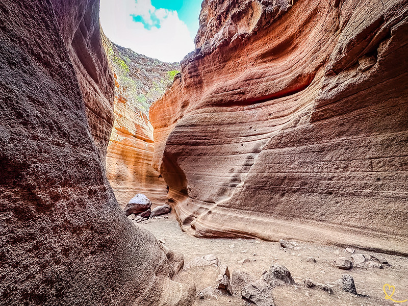
Gran Canaria’s landscapes are truly varied. One of the surprises is the Tobas de Colores slot canyon, reminiscent of the American West. If you’ve never seen one, don’t miss Barranco de Las Vacas! Here are some useful tips to help you get there, prepare for your visit and have a wonderful time!
This opinion is completely independent, based on our experiences. We visited the region anonymously, making our own choices and paying our bills in full.
Content
Is Barranco de las Vacas (Tobas de Colores) worth a visit? Our opinion:
It depends on your previous travel experiences. If you’ve been dreaming of going to Utah to visit the canyons, but haven’t had the chance yet, then yes. The curves created by the water give you a tiny glimpse of the beauty of such landscapes. If, on the other hand, you’ve already visited Utah’s canyons, be warned that it’s very small, and you may be disappointed.
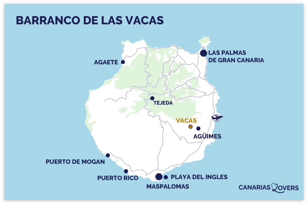
No other option than to drive there. There’s no public transport, and the location isn’t even signposted. The cannon is located along route GC-550 (kilometer 14). The access road is narrow at times, but without any major difficulties. The floor is in good condition. Please note that on some online maps, several dots indicate this location. The trail is at these coordinates: 27°54’51.8 “N 15°28’31.6 “W.
If you want to park easily, we advise you to come early or late in the day. However, if you come too early, the colors of the canyon will be less interesting until the sun is high enough in the sky.
Free access.
Warning: as with all slot canyons, check that there are no thunderstorms in the mountains (in the hours before or during your visit). Because this kind of canyon can have ultra-rapid floods called flash-floods.
Length of visit and main difficulties
The canyon is very small, about 50m long. It only takes 10min to explore once you’re down there, if no one’s around. But if you’re fascinated, allow 1 hour! The descent from the road is a slightly steep but very short dirt path. Walking in the canyon is not very difficult, you just have to watch where you put your feet.
We recommend that you wear closed-toe walking shoes.
Before descending, even if you’re excited to see this canyon, take time to admire the valley, the desert landscape and the surrounding mountains. What a change from seaside landscapes!
Finding the trail
Where the road bends at the bottom of the valley, opposite the 3 parking spaces, you have to climb over the road safety barrier. You’ll notice a path formed by the passage of people. And you can already see the tunnel at the bottom of the path that gives access to this secret place!
Go through the tunnel under the road
Once at the bottom, you must cross the tunnel under the road. Note the rocky road on the left!
Subscribe to our Newsletter
Get away from it all with Region Lovers’ beautiful destinations!
Once a month
Advertising-free
Exploring the Canyon de las Vacas: photos and a bit of geology
Once at the bottom, you can explore the ravine, discovering its shapes sculpted by nature. A few plants are growing inside.
If you’re lucky enough to have a few clouds, you’ll be able to see the colors change when the sun is hidden or not: sometimes pink and gray, sometimes orange and brown. here are a few photos
How was the canyon formed?
The Barranco de las Vacas was formed by natural geological processes over a long period of time, typical of this type of cayon. The rocks in the canyon are volcanic, known as “colored tuffs” or “toscas”, and are typical of the Canary Islands. Over the millennia, water has eroded and sculpted this rock. As water always seeks the path of least resistance, it creates these sinuous shapes…
Hiking S40
The Barranco de las Vacas is a must-see if you’re doing the S-40 hike, which also passes through the charming town of Agüimes. It’s a long hike from Agüimes up into the mountains.
Length: 19km
Difficult
Approximately 6 to 7 hours
Approx. 710m ascent
Other nearby attractions
You can combine your visit to Canyon de las Vacas with these nearby attractions:
The literal translation of the name is Ravin des vaches. Apparently, it is also called Barranco de Barafonso. Tobas de Colores is the name of the narrow section only.
We share everything with you: our favourite places, our tips, our good plans... and without invading you with ads! To bring you the best possible site, cookies are an essential ingredient. Do you accept them? Find out more
Fonctionnel Always active
Le stockage ou l’accès technique est strictement nécessaire dans la finalité d’intérêt légitime de permettre l’utilisation d’un service spécifique explicitement demandé par l’abonné ou l’utilisateur, ou dans le seul but d’effectuer la transmission d’une communication sur un réseau de communications électroniques.
Préférences
Le stockage ou l’accès technique est nécessaire dans la finalité d’intérêt légitime de stocker des préférences qui ne sont pas demandées par l’abonné ou l’utilisateur.
Statistiques
Le stockage ou l’accès technique qui est utilisé exclusivement à des fins statistiques.Le stockage ou l’accès technique qui est utilisé exclusivement dans des finalités statistiques anonymes. En l’absence d’une assignation à comparaître, d’une conformité volontaire de la part de votre fournisseur d’accès à internet ou d’enregistrements supplémentaires provenant d’une tierce partie, les informations stockées ou extraites à cette seule fin ne peuvent généralement pas être utilisées pour vous identifier.
Marketing
Le stockage ou l’accès technique est nécessaire pour créer des profils d’utilisateurs afin d’envoyer des publicités, ou pour suivre l’utilisateur sur un site web ou sur plusieurs sites web ayant des finalités marketing similaires.
Pour offrir les meilleures expériences, nous utilisons des technologies telles que les cookies pour stocker et/ou accéder aux informations des appareils. Le fait de consentir à ces technologies nous permettra de traiter des données telles que le comportement de navigation ou les ID uniques sur ce site. Le fait de ne pas consentir ou de retirer son consentement peut avoir un effet négatif sur certaines caractéristiques et fonctions.
Fonctionnel Always active
Le stockage ou l’accès technique est strictement nécessaire dans la finalité d’intérêt légitime de permettre l’utilisation d’un service spécifique explicitement demandé par l’abonné ou l’utilisateur, ou dans le seul but d’effectuer la transmission d’une communication sur un réseau de communications électroniques.
Préférences
Le stockage ou l’accès technique est nécessaire dans la finalité d’intérêt légitime de stocker des préférences qui ne sont pas demandées par l’abonné ou l’utilisateur.
Statistiques
Le stockage ou l’accès technique qui est utilisé exclusivement à des fins statistiques.Le stockage ou l’accès technique qui est utilisé exclusivement dans des finalités statistiques anonymes. En l’absence d’une assignation à comparaître, d’une conformité volontaire de la part de votre fournisseur d’accès à internet ou d’enregistrements supplémentaires provenant d’une tierce partie, les informations stockées ou extraites à cette seule fin ne peuvent généralement pas être utilisées pour vous identifier.
Marketing
Le stockage ou l’accès technique est nécessaire pour créer des profils d’utilisateurs afin d’envoyer des publicités, ou pour suivre l’utilisateur sur un site web ou sur plusieurs sites web ayant des finalités marketing similaires.