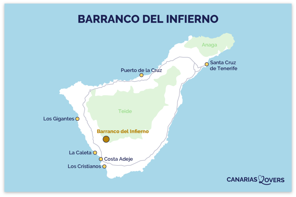
Nestled in the heart of a nature reserve, the Barranco del Infierno hike in Adeje won us over with its magnificent rolling landscapes and well-marked trail. Accessible by reservation only, these impressive gorges offer a spectacular journey through sheer cliffs, lush vegetation and hidden waterfalls.
Find all our useful tips and photos to help you plan your trip and discover incredible views!
This opinion is completely independent, based on our experiences. We visited the region anonymously, making our own choices and paying our bills in full.
Content
Tour summary and map
- Distance: 6.5km (not a loop).
- Duration: 2h30 to 3h for a leisurely round trip and views of the countryside.
- Difficulty: low to medium.
- Ascent: 100m to 1300m.
- Access: limited – booking required here.
- Price: €13 for an adult and €6.50 for a child (aged 5 to 12).
- Opening hours: 8am to 10:30am in summer, 8:30am to 11:30am in winter.
- Equipment: helmet (provided by the site), closed shoes to prevent slipping (not provided).
- Departure: every 30 minutes in small groups (max 20 people).
- Safety: guides positioned at strategic points along the trail.
- Opt for an excursion in the company of an expert guide to explore the local flora and fauna in depth. – see activity details.
You’ll find the map of the trail to help you find your way around:

Is the Barranco del Infierno hike worth it? Our review
Absolutely! The Barranco del Infierno hike impressed us with its exceptional views over the nature reserve. The course is very well supervised. There is a departure every 30 minutes to preserve the local flora and fauna. The path winds its way through the mountains, offering breathtaking panoramic views all the way to the ocean! This lush environment contrasts with the more arid areas of Tenerife. In our opinion, this is one of the most beautiful hikes on the island and one of Costa Adeje’s best attractions!

Our favorite moments:
- The starting point for the hike that offers the best views of the green mountains.
- Crossing the small forest at the bottom of the gorge, where the natural environment evolves.
- The return journey reveals an exceptional panorama of Adeje and the ocean.

OUR GUIDE TO PLANNING A Dream Trip
- Our selection of 112 places so you don’t miss out on the best spots
- An average of 3 photos per location to help you choose
- Clickable links that open GPS navigation directly on your smartphone.
What are the difficulties?
The floor
Although the hike is relatively straightforward, watch where you put your feet. We crossed small streams with slippery bridges, climbed up and down stairs, and skirted narrow passages. The ground is slippery, covered with pebbles and dotted with holes.
Slopes
All ascents and descents traversed on the outward journey must be traversed in the opposite direction on the return journey. If you take your time, you won’t encounter any particular difficulties. Carry hiking poles for extra support if needed. Be aware that the path is sometimes quite narrow and that you’ll have to pass one after the other.
Temperature
Temperatures vary as you hike, depending on altitude. The first and last sections of the route are more exposed to the sun, while the central part, which is shadier and cooler, is marked by a more humid environment. In particular, you’ll pass through the bottom of the gorge. Heat can be intense in the middle of the day, especially in sunny areas. Remember to take water and sun cream to avoid dehydration and burns.

WHERE TO STAY IN Costa Adeje
Our favorites: neighborhoods and hotels
Between La Caleta and Playa del Duque
Hotel La Plantación del Sur – Check photos and availability
Between Playa de Fañabé and Playa del Bobo
Adrián Hotels Jardines de Nivaria – Check photos and availability
On the heights
Hotel Wyndham Residences Costa Adeje – Check photos and availability

See our complete selection of the best hotels in Costa Adeje.
Access to the Barranco del Infierno hike in Adeje
Where to find us – map
- The hike is located in the south-west of Tenerife, in the Barranco del Infierno nature reserve.
- Parking Adeje – Casa Fuerte is an 8-minute walk from the start of the hike (on an incline). It’s not free, but it’s not expensive.
- From Costa Adeje: 15min drive,
- From Playa de las Américas: 20min drive,
- From Los Cristianos: 20min drive.
Our map will help you find your way around the island:
Access by car and parking
To reach the hike from the seaside resorts in the south-west of the island, take the TF-1 main road and exit at Adeje. You then cross the town to the Adeje – Casa Fuerte parking lot, located between Casa Fuerte and the Parroquia de Santa Úrsula. It is located along Calle Tagoror. Some of Ajede’s streets are quite narrow, so we advise you to drive slowly.
You will then have to walk up Calle de los Molinos for about 8min to access the hike. The path is on a slope.

OUR TIPS TO RENT A CAR IN Tenerife
- Compare prices on our preferred platform: DiscoverCars – one of the best rated sites.
- If you’re planning to explore the mountains, don ‘t take the smallest cars. A more powerful engine will be more comfortable.
- But don’t take too big a car either, as some roads are narrow.
- There’s a lot of demand and it’s an island, so book early.

Public transport access
Several bus stops are located in Adeje, the closest to the hike being the “Constitución” stop. It’s a 10-minute walk to the trailhead. For more information, visit the local public transport website here.
Useful tips on hiking
How long and when is the best time to do the trail?
- Allow between 2h30 and 3h to make the round trip at a leisurely pace and fully appreciate the various panoramic views of nature. We took all the time we needed to contemplate the breathtaking scenery of this lush environment!
- Book your tour well in advance, as places are scarce and go very quickly – visit the official website here.
- Choose the early morning slot to limit sun exposure and avoid crowding on the course (although this is strictly controlled).
- Departures are only every 30 minutes in the morning.

The meaning of hiking
The route is linear. There’s no question about the direction of the hike. It’s just a matter of going straight ahead and following the path. Once you’ve reached the waterfall, you’ll have to turn around and retrace your steps.
Hiking with children
The course is very well supervised. It’s open to children aged 5 and over, but you’ll need to take regular breaks to adapt to the pace of younger children, and protect them from the sun (cream, sunglasses, hat). Don’t forget to bring a snack and water if you need them. This hike is featured in our article on the best family attractions in Costa Adeje!

Installations
Toilets are available at the start of the hike. We advise you to stop here, as you won’t come across any others during the trail.
We also noted the presence of Restaurant Otelo, which boasts an exceptional view of the gorges. It seems to be suspended in mid-air. The food is simple and hearty, but the view alone is worth the detour!

Subscribe to our Newsletter
- Get away from it all with Region Lovers’ beautiful destinations!
- Once a month
- Advertising-free

The starting point of the hike

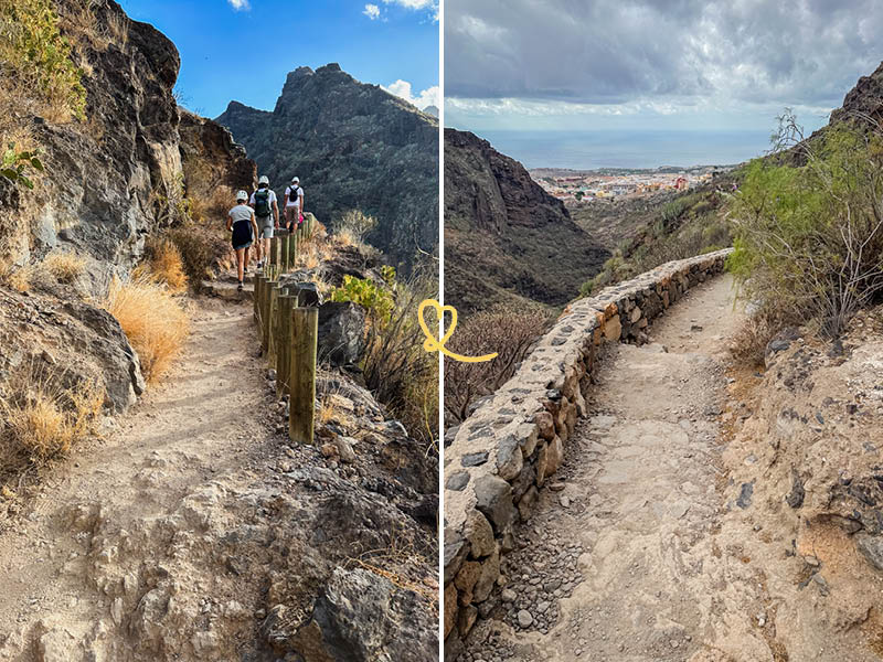
Right from the start of the hike, the tone is set: the first panoramas of the Barranco del Infierno gorges are already breathtaking. Even before we set off on the trail, we were impressed by the unobstructed view of the sheer rock faces that stretched as far as the eye could see. We couldn’t wait to discover the natural wonders to come!

Before starting the adventure, the staff provided us with a helmet in case of falling rocks. After giving us a few details about the circuit, we were ready to set off in small groups. There is a departure every 30 minutes to preserve the local flora and fauna.
The start of the journey

We particularly loved the start of the hike, which reveals breathtaking scenery at every turn. The unique trail winds through lush, unspoilt countryside. We moved quietly one after the other, so as not to jostle each other. Each bend opened up new vistas of the gorge and its lush vegetation. Uneven and strewn with asperities, the floor requires particular attention, but adds to the wild charm of the place.
Viewpoints over the gorges

There are several panoramic viewpoints along the way. Take the time to stop and contemplate the grandiose beauty of the Barranco del Infierno. These lookouts reveal breathtaking views of the gorges, sheer cliffs and local flora, in stark contrast to the island’s aridity. We fully appreciated the majesty of the setting. These breaks also allow you to recharge your batteries and soak up the wild, peaceful atmosphere of the canyon.

Subscribe to our Newsletter
- Get away from it all with Region Lovers’ beautiful destinations!
- Once a month
- Advertising-free
El Bailadero de las Brujas

Along the way, you’ll notice information panels on the local flora and fauna, as well as signs pointing out specific points of interest. One in particular caught our eye: El Bailadero de las Brujas, which means “the place where witches dance”.

This site exudes an enigmatic atmosphere that caught our attention. Curious, we couldn’t resist doing a little research on the subject. It would seem that rites and rituals were performed here, leaving a certain mystery surrounding this fascinating place. We suggest you consult this article for more information. Intriguing, isn’t it?
Crossing the rainforest

After a series of ascents and descents, we reached the bottom of the gorge, where the landscape was much wetter. The view of the surrounding mountains, majestic and imposing, was simply breathtaking. Continuing on, we entered a small shady forest where it was cooler. Crossed by small streams, it marked a striking contrast with the more arid areas seen earlier.

The forest also indicates imminent arrival at the return point. By this stage, we knew we weren’t far from the waterfall. Throughout the hike, the environment changes constantly, from steep cliffs to wooded areas, revealing the natural diversity of the Barranco del Infierno.
Discovering the hidden waterfall

After an hour to an hour and a half’s walk, we finally reached the waterfall. Although we don’t consider it the most spectacular part of the hike, it’s still a haven of peace. The sound of gently flowing water, combined with the gentle murmur of the surrounding nature, makes it an ideal place to recharge your batteries and enjoy the peace and quiet. Take this moment to breathe deeply and reconnect with nature before turning back.
DISCOVER Costa Adeje
- Attractions in Costa Adeje
- Most beautiful beaches
- In the family
- Best hotels
- Best restaurants (coming soon)
- 5-star hotels
- Aqualand

The way back

You’ll see from our photos that the weather changed a little on the way to and from the hike. Previously clear, the sky gradually darkened, transforming the landscape. The cloud cover created a different perspective on the gorge, revealing a more mysterious and intriguing atmosphere.

On both the outward and return journeys, we were struck by the millennia-old irrigation systems along the way. These ancient infrastructures, testimony to ancestral know-how, bear witness to the ingenuity of the local people, who have adapted to the challenges of their environment. These canals carried water from mountain springs to the cultivated land below. The trail runs alongside these canals.
Ocean views

The last vantage points of the hike reveal a spectacular perspective: the ocean looming on the horizon between the walls of the gorge. As we neared the end of the route, these panoramas became more and more impressive. The infinite blue of the water contrasted with the earthy, green hues of the mountains. These ocean views gave us a feeling of freedom, giving the impression that the immensity of the sea extended the landscape into infinity. The interplay of these natural elements formed a striking backdrop, providing a memorable conclusion to our hike.
PLAN YOUR TRIP TO tenerife
- Best of
What to do in Tenerife
Most beautiful towns and villages
Most beautiful beaches
Best natural pools
The most beautiful landscapes
Most beautiful roads
Amusement parks
Best excursions in Tenerife

- Practical advice
25 tips for a successful trip to Tenerife
How to get around
How to rent a car in Tenerife
Driving tips
Best excursions (coming soon)
Where to stay in Tenerife
Itineraries: 3 days – 4 days – 5 days – 6 days – 1 week – 10 days

- The must-dos
Dolphin watching in Tenerife
Teide National Park
Anaga Rural Park (coming soon)
La Orotava
Garachico
Village of Masca
Pyramids of Güimar

